Best Mountain Walks in Conwy: Routes, Parking and Public Transport for Every Level
Published 24 June 2026Updated 1 July 2026by Petruconwyoutdoors
From the volcanic summit of Conwy Mountain to full-day Carneddau ridges — routes for every level with parking, public transport and honest terrain notes.
Conwy sits on the edge of Eryri (Snowdonia) and draws walkers from the volcanic coastal summit of Mynydd y Dref to the drovers’ roads and the waymarked forest trails of Gwydir. Routes span from a 45-minute town walls circuit to a full-day ridge traverse. Every walk below comes with a specific start point, honest terrain notes, and a clear word on parking and public transport.
Conwy Mountain (Mynydd y Dref): The Volcanic Summit Above Town
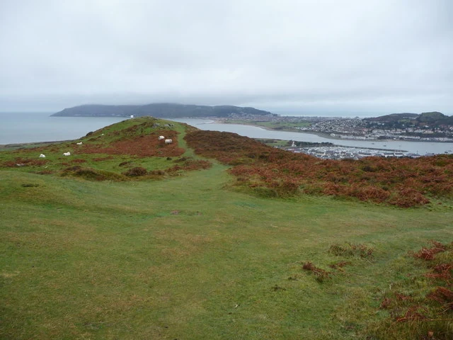
This is the obvious starting point, and it earns that status. Conwy Mountain, known in Welsh as Mynydd y Dref, reaches 244 metres at its summit. The rock beneath your boots is ancient: the mountain is the remains of an extinct volcano that erupted approximately 450 million years ago. Much later, in the Iron Age, a hill fort was constructed along the ridgeline, and those remains are still visible to walkers today.
Two access options cover different needs. Linear route: The standard route starts from the Sychnant Pass car park — a 10-minute drive or steady uphill walk from the town centre. From there, the route to the summit is roughly 3 km return and takes about 90 minutes at a relaxed pace.
Circular walk: The Mountain Road car park sits on the west side of the A547, directly opposite Bodlondeb Park. A sign at the car park reads ‘Mynydd y Dref – Conwy Mountain’, and the circular route from here takes 1.5 to 2 hours. This is the better choice if you want a complete loop rather than retracing your steps.
The summit repays both approaches. On a regular clear day you can see Anglesey, Liverpool, and the Isle of Man. On exceptionally clear days, the mountains of County Wicklow in Ireland are visible on the horizon.
Longer Ridge Routes: Alltwen and ‘Work Those Calves’
Three main mountains make up the immediate coastal walking area around Conwy: Mynydd y Dref, Alltwen, and Penmaenbach. For fitter walkers who want a half-day starting from Conwy town itself rather than a straightforward summit-and-back, two longer routes extend the day considerably.
The Alltwen traverse covers 5 miles with 353 metres of ascent on entirely off-road terrain. It climbs up the edge of Conwy Mountain on the traverse before continuing up to Alltwen, then returns via the Conwy Mountain summit back into Conwy.
The second option earns its unofficial name. The ‘Work Those Calves’ route covers 5.4 miles with 396 metres of ascent, entirely off-road. It starts up a section known as ‘The Steep Way’ before joining the Conwy Mountain ridgeline. This is described as the toughest climbing available in a 5-mile walk from Conwy. On either of these longer routes, allow up to 3.5 hours.
Pay-and-display car parks are available at the base of Conwy Mountain for anyone arriving by car. Both longer routes begin from Conwy town, which also means they remain accessible to visitors arriving by train (see the transport section below).
Gwydir Forest Park: Panorama Walk, Lady Mary’s Walk and the Mining Trails
Gwydir Forest Park, set in the Conwy Valley inland from the coast, offers a different character: waymarked routes through working forest, beside mountain lakes, and across the remains of old lead mining workings.
The Conwy Panorama Walk, managed by Natural Resources Wales, is graded Moderate, covers 3.6 miles (5.8 km), and takes 1½ to 2½ hours. Most of the route follows forest roads, but connecting sections run on rough, narrow paths less than 60 cm wide, with uneven surfaces including mud, rocks, and tree roots.
Lady Mary’s Walk is waymarked from Sawbench car park and named after a Lady Mary from the Wynn family, who bought the land and built up the historic Gwydir Estate. The route passes two sculptures by local artists, one of which is a memorial to the old Llanrwst Town Hall. It also passes through Caerdroia, a community-managed woodland with information panels explaining the work of the group. Five benches are placed along the route, useful if you are walking with older family members or anyone who needs to set their own pace.
Beyond these two main routes, Gwydir Forest Park holds a wider network of waymarked trails. The options include an accessible riverside trail at Llyn Crafnant, a trail around two lakes at Llyn Geirionydd, a short trail around the abandoned Cyffty Mine, the Hafna trail through lead mine ruins, and a walking trail along a Roman road at Dolwyddelan. The mining trails in particular give you genuine industrial history underfoot, without the pressure of a summit-or-bust objective.
Into the Carneddau: Ysbyty Ifan and the Drovers’ Road
Conwy is the practical gateway to the Carneddau. Carnedd Llewelyn straddles the Conwy/Gwynedd boundary, and Pen yr Ole Wen is accessible from the southern edge of the county. For a full-day walk that gives a real sense of the older landscape without requiring technical scrambling, the National Trust’s Ysbyty Ifan and Cwm Eidda Walk is the practical gateway into this terrain.
The route follows an old drovers’ road for 6 miles (9.6 km) and takes 3 to 4 hours. It starts from Ysbyty Ifan car park at grid reference SH842488. Views of Dyffryn Conwy and the Carneddau mountains accompany much of the walk.
Terrain is honest rather than gentle. The route involves steep hills, stiles, gates, rough tracks, uneven ground, and boggy sections. Waterproof boots are not optional. Dogs on leads are welcome.
This is a walk that demands a car. Public transport to Ysbyty Ifan is not a realistic option for most visitors, and that applies to most out-of-town trailheads across the county.
Family-Friendly Walks and Gentler Alternatives
Not every visitor is after ascent. Two routes at different ends of the county work well for families, older walkers, or anyone who wants a rewarding walk without serious exertion.
Conwy Town Walls carry significant history. Allow 45 minutes to 1 hour for the walk. The circuit is manageable for most adults but is not pushchair-friendly, owing to steps and narrow sections.
For a fuller half-day at a gentler pace, the Furnace Wood and Meadow Trail at Bodnant Garden (National Trust) covers 2 miles (3.2 km) and takes 1 to 2 hours. The trail starts from the Old Mill in The Dell at grid reference SH800723, within the 80-acre hillside site in the Conwy Valley. A short detour at the brow of Furnace Hill reveals the River Conwy running through the valley towards the sea. Dogs are welcome on designated dogs-welcome days from 1 April, and every day from October to the end of March.
Parking, Public Transport and Getting to the Trailheads
Here are the four verified parking points matched to their walks:
1. Mountain Road car park, west side of the A547, directly opposite Bodlondeb Park, Conwy town. Start point for the Conwy Mountain circular walk (1.5–2 hours), signed ‘Mynydd y Dref – Conwy Mountain’.
2. Sychnant Pass pay-and-display, a 10-minute drive from Conwy town centre, or a steady uphill walk. Start point for the 3 km return Conwy Mountain summit route (approximately 90 minutes).
3. Sawbench car park, Gwydir Forest Park, start point for Lady Mary’s Walk.
4. Ysbyty Ifan car park (grid ref SH842488), National Trust drovers’ road walk, 6 miles, 3 to 4 hours.
Public transport: Conwy town is served by train, but public transport to mountain and forest walking areas in the wider Conwy Valley is limited, making a car realistically necessary for most out-of-town trailheads. The Conwy Mountain circular via Mountain Road and the Town Walls circuit are the most practical options if you are arriving without a car, as both start within or very close to the town.
Cyclists: NCN Cycle Route No. 5 passes within 150 metres of Conwy Town Walls.
---
If you are planning an overnight stay around your walk, the North Wales Local accommodation directory for Conwy lists B&Bs, hotels, and self-catering options across the county. For food after coming off the hill, pubs and restaurants in Conwy are listed there too.
---